Executive Secretary

10th International Scientific Conference on Agricultural Development and SustainabilityAGROCENTRO 2023
Agrocentro 2021
Abstract
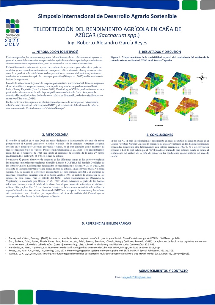
The study was carried out in 2021 in areas dedicated to the production of sugar cane belonging to the "Cristino Naranjo" Sugar Mill of the Holguín Sugar Company, located in the Cacocum municipality, Holguín province, in the area known as Yaguabo, with the objective of to determine the relationship between the NDVI spectral index and the sugarcane crop yield. 32 random sampling points were drawn in the different months in which the satellite images belonging to the USGS Landsat 8 OLI / TIRS satellite were chosen, and the downloaded images are found in the WGS 84 UTM Zone 18 North system in grid 011 / 046 covering the study area. In the QGIS software "A Coruña" version 3.10, the radiometric correction of each satellite image and the sampling scheme presented was carried out, while the ArcGIS 10.5 software extracted the values of each point after the calculation of the NDVI. Statistical software Stargraphics Plus 5.0 was used; in which the linear regression analysis was carried out between the values obtained from the NDVI at each sampling point and the real yield values offered by specialists from the Central's analysis area that correspond to the dates of the images used. The determination of the vegetative index NDVI shows values from 0 to 0.5, there is little vegetation in the study area. The coefficient of determination indicates that the model explains 97.8598 of the variability of performance. The use of NDVI can be used for studies where the yield of the sugarcane crop is estimated in the edaphoclimatic conditions of the study area.
Resumen
El estudio se realizó en el año 2021 en zonas dedicadas a la producción de caña de azúcar perteneciente al Central Azucarero “Cristino Naranjo” de la Empresa Azucarera Holguín, ubicado en el municipio Cacocum provincia Holguín, en el área conocida como Yaguabo, con el objetivo de determinar la relación existente entre el índice espectral NDVI y el rendimiento del cultivo de la caña de azúcar. Se trazaron 32 puntos aleatorios de muestreo en los diferentes meses en los que se escogieron las imágenes satelitales pertenecientes al satélite Landsat 8 OLI/TIRS del USGS, y las imágenes descargadas se encuentran en el sistema WGS 84 UTM Zona 18 Norte en la cuadrícula 011/046 que abarca la zona de estudio. En el software QGIS “A Coruña” versión 3.10 se realizó la corrección radiométrica de cada imagen satelital y el esquema de muestreo presentado, mientras que el software ArcGIS 10.5 se realizó la extracción de los valores de cada punto luego del cálculo del NDVI Para el procesamiento estadístico se utilizó el software Stargraphics Plus 5.0; en el cual se realizó el análisis de regresión lineal entre los valores obtenidos del NDVI en cada punto de muestreo y los valores del rendimiento real ofrecidos por especialistas del área de análisis del Central que se corresponden a las fechas de las imágenes utilizadas. La determinación del índice vegetativo NDVI muestra valores desde 0 hasta 0,5 se presenta una escasa vegetación en el área de estudio. El coeficiente de determinación indica que el modelo explica el 97,8598 de la variabilidad del rendimiento. El uso del NDVI puede ser utilizado para estudios donde se estime el rendimiento del cultivo de la caña de azúcar en las condiciones edafoclimáticas del área de estudio.
About The Speaker

Prof. Roberto Alejandro García Reyes

Discussion