Executive Secretary

19th International Symposium of Electrical Engineering
SIE 2021
Abstract
In this work, a transmission system of geographic coordinates is developed by radiofrequency, which allow to know in real time the location of the maritime means of transport. It is part of the commercially transmitted port of the AIS (Automatic Identification System), then a computer, an interface and an ultra-cutting wave transceiver, the data is sent in a wireless wave For this, the following designs were made: application for PSK modulation of the data obtained from the AIS receiver, connection interface between the computer port of the computer and the transceiver, application for representation of the objectives. This work gives to institutions of the country, which employ such a transport, a mechanism with existing technology to bring trajectory control of their boats. Scientific research methods will be applied in the research process: theoretical, empirical and statistical. Taking into account the developed system, it can be concluded that Cuba has the potential to create its own naval monitoring applications to meet its needs. Although AMEC manufacturer hardware was used, there are other AIS receiver devices from various manufacturers on the market, which do not have high costs, which allows the development of a good monitoring system with minimal costs.
Resumen
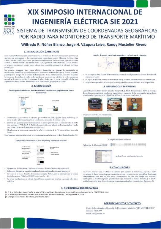
En el presente trabajo se desarrolla un sistema de transmisión de coordenadas geográficas por radiofrecuencia, las cuales permiten conocer en tiempo real la ubicación de los medios de transporte marítimo. Se parte de la información transmitida por puerto serie de los receptores AIS (Automatic Identification System) comerciales, luego a través de un sistema conformado por una computadora, una interfaz y un transceptor de onda ultracorta se envían los datos de forma inalámbrica a los centros de control de tráfico naval, los cuales son dotados de un software que recibe los datos procedentes del radio y los representa en un mapa virtual. Para ello se realizaron los siguientes diseños: aplicación para modulación PSK de los datos obtenidos del receptor AIS, interfaz de conexión entre el puerto de audio de la computadora y el transceptor, aplicación para representación de los objetivos. Este trabajo entrega a instituciones del país, que emplean transporte de ese tipo, un mecanismo con tecnología existente para llevar control de trayectoria de sus embarcaciones. En el proceso investigativo serán aplicados los métodos de investigación científica: teóricos, empíricos y estadísticos. Teniendo en cuenta el sistema desarrollado, se puede llegar a la conclusión de que Cuba tiene el potencial para confeccionar sus propias aplicaciones de monitoreo naval, para suplir sus necesidades. Aunque se utilizó un hardware del fabricante AMEC, en el mercado existen otros dispositivos receptores AIS de diversos fabricantes, los cuales no tienen costos elevado, lo que permite el desarrollo de un buen sistema de monitoreo con costos mínimos.
About The Speaker

Wilfredo Rafael Núñez Blanco


